35mm Color Slide Photographic Item
Title
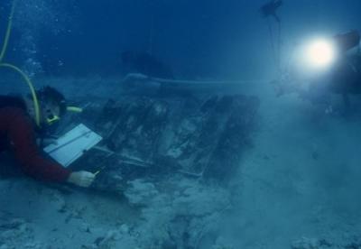
Mapping the Henrietta Marie Hull StructureAccession Number
2018.002.0602Creation Date
2001Description
National Geographic photographer Courtney Platt (right) photographing archaeologist David Moore mapping the Henrietta Marie hull structure underwater. Mel Fisher Maritime Heritage Society archaeologist Corey Malcom dredging the Henrietta Marie hull structure in the background.